Trail Walking Eschenbach (SG) - hike21 - Photo

Optez pour le retour à la nature GUIDE+
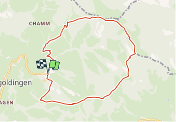
© OpenStreetMap contributors
Length
Length
9.1 km
Max alt
Max alt
1315 m
Uphill gradient
Uphill gradient
588 m
Km-Effort
Km-Effort  
17 km
Min alt
Min alt
823 m
Downhill gradient
Downhill gradient
594 m
Boucle
Boucle
Yes
Creation date :
2014-12-10 00:00:00.0
Updated on :
2014-12-10 00:00:00.0

(0 Reviews)

Walking
Walking
--
Difficulty : Unknown

Scan this QR Code to open this trail in the SityTrail application

FREE GPS app for hiking

Logo SityTrail SityTrail

IGN / Geographical institutes

Download SityTrail from the App Store Download SityTrail from Google Play

Logo SityTrail SityTrail Plus

The world is yours!

Download SityTrail from the App Store Download SityTrail from Google Play Download SityTrail on Huawei AppGallery

About

Trail Walking of 9.1 km to be discovered at Sankt Gallen, Wahlkreis See-Gaster, Eschenbach (SG). This trail is proposed by My Switzerland.

Elevation profile

Points of interest

Point of interest Eschenbach (SG) - Schutt - Photo
My Switzerland
ESCHENBACH (SG) 
Point of interest Eschenbach (SG) -  - Photo
My Switzerland
ESCHENBACH (SG) 
Point of interest Eschenbach (SG) -  - Photo
My Switzerland
ESCHENBACH (SG) 
Point of interest Eschenbach (SG) -  - Photo
My Switzerland
ESCHENBACH (SG) 
Point of interest Wattwil -  - Photo
My Switzerland
WATTWIL 
Point of interest Eschenbach (SG) -  - Photo
My Switzerland
ESCHENBACH (SG) 
Point of interest Eschenbach (SG) - Schutt - Photo
My Switzerland
ESCHENBACH (SG) 

Positioning

Country:
Switzerland
Region :
Sankt Gallen
Department/Province :
Wahlkreis See-Gaster
Municipality :
Eschenbach (SG)
Location:
Unknown
Start:(UTM)
499678 ; 5236780 (32T) N.


Close
My subscriptions